⚓ Monograph Overview: The Master Navigators of the Pacific
Between 1500 BCE and 1000 CE, Polynesian voyagers colonized the vast Polynesian Triangle—an oceanic territory of over 10 million square miles spanning from Hawaii in the north to New Zealand (Aotearoa) in the southwest and Easter Island (Rapa Nui) in the southeast. Accomplished entirely without metal tools, compasses, or written charts, Polynesian wayfinding utilized a sophisticated cognitive system of sidereal star compasses, ocean swell interference matrices, bird behavior, and bioluminescence.
Long before European mariners dared to venture beyond the sight of coastal headlands, ancient Austronesian and Polynesian navigators were successfully colonizing the largest body of water on planet Earth. The Pacific Ocean covers more than 63 million square miles—surpassing the land area of all Earth’s continents combined. Scattered across this gargantuan aqueous expanse are tiny volcanic islands and coral atolls, often separated by thousands of miles of open, storm-swept sea.
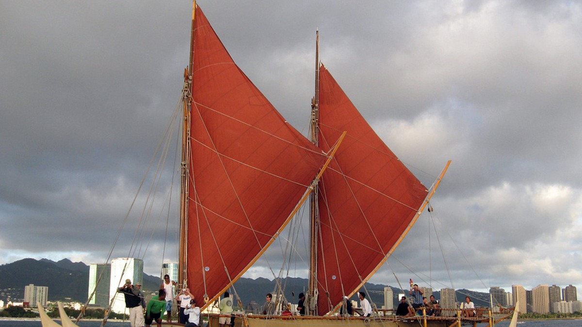
Between approximately 1500 BCE and 1200 CE, in double-hulled voyaging canoes (such as the Hawaiian wa’a kaulua) constructed from lashed timbers and powered by pandanus-leaf sails, Polynesian voyagers completed one of the most astonishing human migration sagas in history. They systematically explored, colonized, and maintained reciprocal trading networks across the Polynesian Triangle, whose vertices encompass Hawaii, New Zealand (Aotearoa), and Easter Island (Rapa Nui).
For centuries, Eurocentric historians and anthropologists, notably Thor Heyerdahl in his 1947 Kon-Tiki expedition, dismissed the idea that Polynesians could intentionally navigate against prevailing trade winds and currents, arguing instead that the islands were populated through accidental drift voyages. However, the renaissance of non-instrument navigation spearheaded by Micronesian master navigator Mau Piailug and the voyage of the Hōkūleʻa in 1976 decisively proved that Polynesian wayfinding was an empirical, repeatable, and mathematically rigorous science of cognitive mapping and environmental literacy.
1. The Sidereal Star Compass: Mapping the Horizon
The foundational framework of Polynesian wayfinding is the sidereal star compass. In traditional Pacific navigation, the horizon is conceived not as a blank boundary, but as a circular dial divided into 32 distinct quadrants or ‘houses’ (whare in Māori, hale in Hawaiian). Because the Earth rotates on its axis, every star rises from the eastern horizon at a specific geographic azimuth, arcs across the sky, and sets at the exact symmetrical point on the western horizon.
Unlike Western compasses that utilize magnetic north (which varies based on geographic position and magnetic declination), the Polynesian star compass is anchored directly to the celestial cosmos. Master navigators memorized the rising and setting positions of hundreds of stars throughout the annual seasonal cycle. Crucially, a star’s declination remains fixed; therefore, a star that rises at a specific point on the horizon will always rise at that exact house regardless of where the canoe is located within the tropical Pacific.
Star Paths (Etak) and Mental Dead Reckoning
At night, navigators steer by aligning the bow and stern of the voyaging canoe with specific ‘star paths’ (a sequence of rising or setting stars following the same trajectory). If the horizon is obscured by clouds, the navigator shifts their sight to stars crossing the zenith (the point directly overhead). Every Polynesian island group has its own unique zenith star—a star whose celestial declination matches the island’s latitude.
For example, the bright red giant star Arcturus (known in Hawaii as Hōkūleʻa, ‘Star of Joy’) passes directly through the zenith of the Hawaiian Islands (declination +19° 12′ N). When voyagers sailing north from Tahiti observed Arcturus passing directly overhead at night, they knew with absolute certainty that they had reached the latitude of Hawaii; they then turned west and ‘sailed down the latitude’ until making landfall.
| Wayfinding Component | Physical Environmental Phenomenon | Navigational Data Extracted | Operational Methodology |
|---|---|---|---|
| Sidereal Star Compass | Rising and setting azimuths of 32 star houses | True geographic heading and angular bearing | Aligning canoe hull with star paths and horizon houses |
| Zenith Stars (Pito Stars) | Stellar declination matching island latitude | Absolute latitude without sextants or tables | Observing star passing directly overhead through mast |
| Ocean Swell Matrices | Deep-sea swell reflections, refraction, diffraction | Constant heading during overcast days & storms | Physical sensing of hull pitch/roll momentum on crossbeams |
| Pelagic Seabirds | Noddy terns (Noio) and White terns (Manu-o-Kū) | Proximity and bearing of unseen landmasses | Tracking dawn departure & twilight homing flight lines |
| Atmospheric Cloud Glow | Green/teal underside reflection on cloud banks | Detection of hidden low-lying coral atolls | Visual scanning of horizon cloud bases for lagoon tint |
| Phosphorescence / Te Lapa | Subsurface bioluminescent light flashes | Deep underwater oceanic currents & island roots | Nighttime observation of flashes pulsing toward land |
2. Ocean Swell Analysis: The Art of Feeling the Sea
While stars provide infallible directional bearings on clear nights, equatorial ocean crossings frequently experience days of impenetrable cloud cover and rain squalls. Under these overcast conditions, navigators rely upon the most sophisticated physical sense in wayfinding: ocean swell analysis.
Navigators distinguish sharply between temporary, wind-driven surface waves (which change rapidly with shifting local breezes) and deep-sea swells. Swells are colossal, long-period energy waves generated by distant planetary weather systems—such as trade winds, Antarctic storms, and sub-polar low-pressure fronts—that travel thousands of miles across ocean basins without changing direction or rhythm.
Sensing the Swell Through the Canoe’s Motion
A voyaging canoe sailing across the tropical Pacific constantly encounters two, three, or four intersecting swell trains simultaneously. Master navigators, such as Mau Piailug and Nainoa Thompson, learned to identify each discrete swell system by lying down on the central platform of the canoe or placing their hands against the hull strakes, physically feeling the unique harmonic roll, pitch, and yaw imparted to the twin hulls.
By keeping the primary trade swell (such as the northeast or southeast trade swell) striking the canoe at a constant angle across the hull—for instance, three finger-widths off the starboard quarter—the navigator can maintain a dead-straight course for days on end without ever seeing the sun or stars.
3. Reading Land Signs: Expanding the Target Island
One of the greatest misconceptions regarding Polynesian navigation is the assumption that navigators had to strike a tiny, two-mile-wide atoll dead center in the middle of a vast ocean. In reality, wayfinders utilized an environmental technique known as ‘expanding the target’. While an isolated atoll may be invisible beyond ten miles, the physical presence of that island generates an environmental signature that expands its detectable radius to over thirty to fifty miles in every direction.
The most reliable living indicators of land are pelagic seabirds, specifically the White Tern (Manu-o-Kū) and the Brown Noddy (Noio). These birds do not sleep on the water; they nest exclusively on dry land and fly out to sea every morning to fish. In the morning, navigators watch the direction from which the birds fly; in the late afternoon (twilight), they track the birds flying directly back toward their island roosts. Observing five or more noddy terns flying in formation provides an absolute vector to unseen land within thirty miles.
Island Swell Shadowing and Cloud Tinting
Islands also create distinct hydrodynamic disturbances in oceanic swells. When a continuous swell train encounters an island mass, the energy waves bend around the landforms through refraction and diffraction, colliding behind the island to produce unique cross-chop swell patterns. Experienced navigators recognize this localized turbulence immediately, knowing they have entered the ‘wake’ or ‘shadow’ of an island.
Furthermore, in the intense tropical sun, shallow, turquoise-water coral lagoons reflect upward against the undersides of high cumulus cloud banks, producing a distinct greenish-teal tint (known in Hawaiian as kūkaepaoa) visible across the horizon long before the low-lying palms break the sea surface.
⚓ Anthropological Milestone: Mau Piailug and the Hōkūleʻa
By the early 1970s, traditional wayfinding had nearly vanished from Polynesia. In 1976, Mau Piailug, one of the last initiated master navigators (Pwo) from the tiny Micronesian atoll of Satawal, agreed to navigate the Hawaiian double-hulled canoe Hōkūleʻa on a 2,500-mile voyage from Hawaii to Tahiti without instruments. His successful voyage proved non-instrument navigation to the modern world and ignited a cultural renaissance across Oceania.
4. The Marshallese Stick Charts: Physicalizing Marine Hydrodynamics
In the Marshall Islands of Micronesia, ancestral navigators developed one of the most remarkable physical mnemonic devices in maritime history: the stick chart (known locally as Mattang, Meddo, and Rebbelib). Constructed from curved palm ribs bound together with coconut sennit fibers, and incorporating small white cowrie shells to indicate island locations, these charts did not depict geographic distances like Western maps.
Instead, stick charts were physical models of wave physics. The bent palm ribs represented the curvature of ocean swell fronts as they were bent, refracted, and deflected by coral atolls. The Mattang was an instructional tool used to teach apprentice navigators the theoretical geometry of swell reflection, while the Rebbelib mapped massive archipelago-wide swell interactions across the entire Marshall Island chain. Because stick charts were cognitive models rather than navigational tools taken to sea, navigators memorized their intricate curves before departure, carrying the hydrodynamic map entirely within their minds.
5. Modern Significance and the Global Wayfinding Renaissance
Today, Polynesian wayfinding is celebrated as one of the supreme intellectual achievements of human maritime culture. The Polynesian Voyaging Society (PVS), established in Hawaii, has sailed the Hōkūleʻa over 150,000 nautical miles across the globe, including the historic Mālama Honua Worldwide Voyage (2014–2017), which circumnavigated planet Earth utilizing traditional non-instrument wayfinding techniques.
Beyond its cultural and anthropological triumph, wayfinding offers profound ecological insights for twenty-first-century navigation. In an era dominated by automated GPS screens and digital disconnection from nature, traditional wayfinding demands profound, multi-sensory immersion in the ocean biosphere. It reminds humanity that the sea is not an empty, hostile void to be conquered, but an interconnected living highway written in the language of the wind, the waves, and the stars.
6. Canoe Hydrodynamics and Double-Hull Architecture (Wa’a Kaulua)
The physical platform that enabled Polynesian voyagers to survive thousand-mile Pacific crossings was the double-hulled voyaging canoe (known in Hawaii as the wa’a kaulua). Consisting of two parallel hulls carved from giant koa or breadfruit logs linked by flexible arched crossbeams (ʻiako) lashed with hundreds of fathoms of hand-braided coconut sennit cordage, the design achieved extraordinary hydrodynamic stability without the deep ballast keels used on European ships.
The twin hulls acted as natural outriggers for one another, virtually eliminating the risk of capsizing in towering equatorial swells. Furthermore, the flexible lashing system allowed the canoe to twist and articulate organically under dynamic wave impact, dissipating thousands of foot-pounds of wave energy that would have shattered a rigid timber hull. Rigged with oceanic lateen or crab-claw sails (lā) woven from pandanus leaves, these canoes achieved cruising speeds of seven to nine knots, easily out-sailing contemporary European exploration caravels.
| Voyaging Vessel Component | Traditional Material Used | Engineering Function | Hydrodynamic Advantage |
|---|---|---|---|
| Twin Hulls (Kaulua) | Acacia koa / Artocarpus altilis | Displacement buoyancy and payload holds | Extreme stability without heavy stone ballast |
| Crossbeams (ʻIako) | Hau (Hibiscus tiliaceus) timber | Flexible structural bridge between hulls | Absorbs torsional wave torque across open ocean |
| Lashing Sennit (ʻAha) | Braided coconut husk fibers | Elastic structural joints connecting beams | Self-tightening when wet; zero metal corrosion |
| Crab-Claw Sail (Lā) | Woven Pandanus (Lauhala) matting | High-vortex aerodynamic lift generation | Generates superior vortex lift when sailing close-hauled |
| Steering Paddle (Hoe Uli) | Solid carved Koa hardwood | Hydrodynamic centerline steering foil | Deep water blade acts as temporary leeway daggerboard |
7. Modern Experimental Voyages of Hōkūleʻa: Validation of Traditional Knowledge
Between 1976 and the present day, the Polynesian Voyaging Society (PVS) has conducted extensive empirical validations of non-instrument wayfinding. Sailing the Hōkūleʻa across more than 150,000 nautical miles of open Pacific waters without modern magnetic compasses, sextants, or satellite positioning systems, master navigator Nainoa Thompson documented that traditional wayfinding operates as an integrated cognitive model.
Every observation—the angle of rising stars relative to the canoe crossbeams, the color of twilight horizon clouds, the flight directions of noddy terns, and the kinetic heave of deep ocean swells—is continuously integrated into a mental coordinate matrix. By proving that ancient voyagers could repeatedly strike tiny Pacific target atolls with less than 1% positional error over 2,500-mile ocean crossings, modern experimental voyaging has permanently established Polynesian wayfinding as one of humanity’s supreme intellectual and navigational achievements.